
Accessing the Planet's imagery (NICFI's) for analysis from Google Earth Engine (GEE)
 for analysis from Google Earth Engine (GEE)")
Users can now access Planet's high-resolution, analysis-ready mosaics of the world's tropics through Norway's International Climate & Forests Initiative (NICFI) with an objective to help reduce and reverse the loss of tropical forests, combat climate change, conserve biodiversity, and facilitate sustainable development for non-commercial purposes.
This program is launched in partnership with Norway's International Climate and Forest Initiative (NICFI), Kongsberg Satellite Services (KSAT), and Planet.
Please, go to this link: https://www.planet.com/nicfi/#sign-up for signing up. You have to fillup the form, and it will guide you on how to proceed with accessing data. For details and accessing the data, please do visit:
Before we move on, we need details of resolution and band information of the planet image. Here's the detail:
Resolution
4.77 meters
Bands:
| Name | Min | Max | Scale | Description |
|---|---|---|---|---|
B |
0 | 10000 | 0.0001 |
Blue |
G |
0 | 10000 | 0.0001 |
Green |
R |
0 | 10000 | 0.0001 |
Red |
NIR |
0 | 10000 | 0.0001 |
Near-infrared |
Now I will move on to sample code with python, demonstrating how we can use it in the Google Earth Engine (GEE) platform.
-
Import Earth Engine module for python API
import geemap, ee # For authentication, Please load this # first time load will suffice # ee.Authenticate() # Initialize the GEE Api with already verified credentials. # This works only if you have authenticated the GEE initally ee.Initialize() - Define area of interest
# get our Nepal boundary aoi = ee.FeatureCollection("FAO/GAUL/2015/level0").filter(ee.Filter.eq('ADM0_NAME','Nepal')).geometry() - Planet & NICFI Basemaps for Tropical Forest Monitoring - Tropical Asia
Earth Engine Data CatLog
Note: You must have access to this data from planet portal, else you will recieve an error. You can sign up and get details from this portal: https://www.planet.com/nicfi/nicfi = ee.ImageCollection('projects/planet-nicfi/assets/basemaps/asia') - I have added Sample Vegetation indices for testing:
def getNDVI(image): # Normalized difference vegetation index (NDVI) ndvi = image.normalizedDifference(['N','R']).rename("NDVI") image = image.addBands(ndvi) return(image) - Filter image for desired dates and apply map function
# Filter basemaps by date and get the first image from filtered results basemap= nicfi.filter(ee.Filter.date('2021-02-01','2021-07-01')).map(getNDVI).first() - Visualization of planet imageries
color = ['FFFFFF', 'CE7E45', 'DF923D', 'F1B555', 'FCD163', '99B718',
               '74A901', '66A000', '529400', '3E8601', '207401', '056201',
               '004C00', '023B01', '012E01', '011D01', '011301']
pallete = {"min":0, "max":1, 'palette':color}
# initialize our map map1 = geemap.Map() map1.centerObject(aoi, 8) map1.addLayer(basemap.clip(aoi), {"bands":["R","G","B"],"min":64,"max":5454,"gamma":1.8}, "mosiac-false-color-planet") map1.addLayer(basemap.clip(aoi), {"bands":["N","R","G"],"min":64,"max":5454,"gamma":1.8}, "mosiac-planet") map1.addLayer(basemap.clip(aoi).select('NDVI'), pallete, "NDVI") map1.addLayerControl() map1
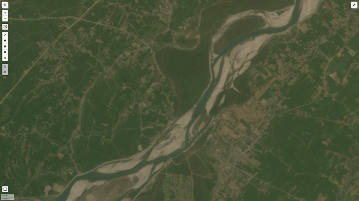
True color planet imaged visualized from GEE.
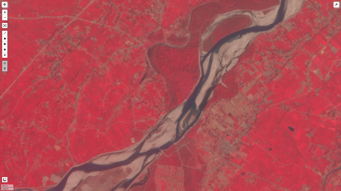
False color composite of planet image on GEE
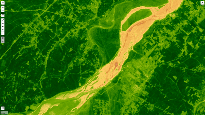
NDVI image for planet image on GEE
Source code: github_link
Please let us know your thoughts on this with following comment section we will definetly reach out to you on your query and feedback.
0 Comments